This post is also available in: Français
Our 80 km trail network is located North West of Montreal in the Harrington, Wentworth North and Gore area. The trails run near Harrington, Laurel, Lakefield, Pine Hill. Take note that we work hard to run trails away from the inhabited area, and most are.
Anyone that has the proper Access Permit can use the trails of any club. See info on https://www.fcmq.qc.ca/en/trail-permit/line-trail-permits
Snowmobile access
- To the northern part of our network, using Quebec’s TransQuébec trail TQ-43 which connects directly to our network at Lac des Seizes-Îles to Club Diable et Rouge.
- To the southern part of our network: using Quebec’s TransQuébec trail TQ-3 if coming from the west, by using Club Argenteuil‘s trails, near the municipality of Grenville. (These access points are closed this season, check their clubs website or social media for updates. 2023-2024)
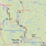 Click on this button map to view our map for a regional view of our trail network. See also the many services accessed from our trails. For a broader view of Quebec’s whole trail network, see the FCMQ map; you may zoom in – a double click on a specific area will center and zoom in at that area e.g. Lac Louisa or Pine Hill north of Lachute.
Road access
You may use a car (& trailer) parking to access our trails at :
HÔTEL DU CHASSEUR : 450-533-5555
38 Chemin St-Michel Road, Brownsburg/Chatham (Pine Hill), Qc, Canada